Those who claim that western Oklahoma is flat and featureless must have never taken a drive out west, and they certainly have never scuffed up a pair of boots at the Packsaddle Wildlife Management Area.
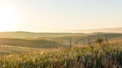
Covering almost 20,000 acres in northwest Oklahoma’s Ellis County, Packsaddle is one of the most scenic areas in the state. The meandering South Canadian River sets the southern boundary for the area as it slopes gently at first and later quite steep to the north where a mixed-grass prairie with shinnery oak dominates. Everywhere in between, there are scenic vistas, a diversity of plants and trees, and wildlife - lots of wildlife.
Although there is a wide range of wildlife at Packsaddle, the bobwhite quail is the undisputed king. The native grasses, sandy soils, and huge blocks of contiguous habitat on the area are a time-tested recipe for producing quail like few other areas in the United States. The secret is out among hunters. On any given late-January day, one might see license plates from Minnesota, Georgia, or Ohio, plus hunters from Ada, Durant, or Okmulgee. As an added bonus to a trip to Packsaddle, hunters can travel 20 minutes to the north to Ellis County WMA or 20 minutes to the south to Black Kettle WMA. The three areas cover over 55,000 acres of first-rate quail habitat. Wildlife Department personnel recognized the unique potential of the area and purchased the 6,500 acre Dunn Ranch in the late 1980s when the property came up for sale. In the following years, the Wildlife Department purchased other surrounding properties from willing sellers, and the area was opened to sportsmen in 1990. Since then it has slowly grown over the years into the almost 20,000 acres it is today.
The land had been well cared for and there was no massive restoration effort necessary when the Wildlife Department assumed ownership. Instead, area biologists could focus on making the area even better for wildlife. Biologists initiated a prescribed burning program, planted trees, and began strip disking, and built food plots. With grants from the National Wild Turkey Federation, biologists removed invasive red cedars and salt cedars along the river to enhance, and in the hopes of, establishing new turkey roost sites. There are a few wetland development units that have been constructed through a partnership with Ducks Unlimited. Quail Forever has also pitched in to support area staff in a variety of ways. Packsaddle has also made its mark as a hub for wildlife research.
While quail may be king at Packsaddle, there is plenty of room for other wildlife in the kingdom. Packsaddle is also very popular for turkey hunting. Additionally, deer hunters harvest a good number of deer each year off of the area, including the occasional wall-hanger buck. On a rare occasion. a hunter may even spot a mule deer The area is open for all three types of hunting - archery, muzzleloader, and gun. Although the first 7 days of the 9 day gun season is restricted to antlered deer only.
Whatever game species you are after, bring your hiking boots. The area has few interior roads. This offers plenty of opportunities for hunters to "get away from it all" and find new areas to pursue game.
The Packsaddle Wildlife Management Area is an Oklahoma treasure. Make plans to head out on an adventure and you just might make a memory that will last a lifetime
Where did the name “Packsaddle” come from?
No one really knows for sure, although there are plenty of good guesses and speculation. The consensus is that early settlers called the South Canadian River crossing (where the Highway 283 bridge is today) the Packsaddle crossing. Crossing the river was once much more of a chore than it is today, and the narrow, shallow area of the river served as a natural funnel for settlers heading north or south to Ellis or Roger Mills counties.
Some say it was called the Packsaddle crossing because the terrain formed the shape of a saddle, while others say the name came from the story of a pack saddle that was left on the bank by an army soldier fleeing a band of Indians.
Home on the Range
In 2000, the Oklahoma Archeological Survey completed a survey of Packsaddle Wildlife Management Area. They found 47 different sites where people had once lived or worked. About half of those areas were old homesteads dating back to the early 1900s. Many of the early settlers found the land ill-suited for growing crops and moved on. The surveyors also found evidence that American Indians came through the area to collect stones for arrowheads and other tools.
Packsaddle at a Glance
- Area Description: Packsaddle WMA covers19,659 acres. and is located in Ellis County 17 miles south of Arnett on Highway 283. Located in the mixed-grass prairie. it is a mixture of rolling sand hills and wooded bottoms with the South Canadian River as its southern boundary.
- Uplands sites are vegetated with mixed grass species including big bluestem, Indian grass, little bluestem, side-oats grama, and buffalo grass and brush species like shinnery oak, sagebrush, and sand plum. Bottomlands are dominated by cottonwood, elm, and hackberry trees. The average annual precipitation for the area is about 25 inches.
- Description of Wildlife Management Practices: Management efforts focus to increase the diversity and abundance of native flora and fauna. This is worked toward by utilizing a variety of habitat management techniques to produce native cover plants and wildlife foods such as ragweed and sunflower, although some small agricultural food plots are planted annually. A controlled burning program has been implemented. Cattle grazing is used to increase quail food abundance and improve brood habitat. Moist soil management for waterfowl is limited to wetland development units. Mechanical control of unfavorable woody plants and invasive plant removal. Vehicle access is limited with few interior roads open to the public.
- Camping and Facilities: Designated primitive camping areas are located on the area. Both lodging and restaurants are available 17 miles north in Arnett and 22 miles south in Cheyenne.