
Page 23 - 2020 - 2021 Oklahoma Hunting & Fishing Regulations
P. 23
TROUT AREA INFORMATION
TR O U T AR E A I N F O R M A TI O N
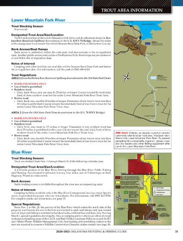
Lower Mountain Fork River SPILLWAY
SH 259A BROKEN BOW RESERVOIR
Trout Stocking Season
Year-round.
Designated Trout Area/Size/Location
Twelve-mile portion of the Lower Mountain Fork River and its tributaries from the Bro-
ken Bow Reservoir Spillway downstream to the U.S. HWY 70 Bridge. About five miles AREA 1
of this designated trout stream lies within Beavers Bend State Park, in McCurtain County. Spillway downstream
BEAVER’S BEND to Old State Park Dam
STATE PARK
Bank Access/Boat Ramps
Bank access is unlimited within the state park and downstream to the re-regulation SH 259A OLD STATE PARK
dam. Another public access point exists at Presbyterian Falls. Boat ramps are just upstream DAM
of and below the re-regulation dam.
Notes of Interest
Camping and cabin facilities are available within Beavers Bend State Park and below
the re-regulation dam. For information, call the park at (580) 494-6300.
N
Trout Regulations AREA 2
AREA 1 (from the Broken Bow Reservoir Spillway downstream to the Old State Park Dam): Old State Park Dam
downstream to
U.S. HWY 70 Bridge
• BARBLESS HOOKS ONLY
• Use of bait is permitted RE-REGULATION DAM
• Rainbow trout
» Daily limit: three; only one may be 25 inches or longer. Counts toward the total daily
limit of three rainbow trout for the entire Lower Mountain Fork River Trout Area.
• Brown trout
» Daily limit: one, must be 30 inches or longer. Possession of any brown trout less than
30 inches is prohibited. Counts toward the total daily limit of one brown trout for the
entire Lower Mountain Fork River Trout Area. PRESBYTERIAN FALLS
AREA 2 (from the Old State Park Dam downstream to the U.S. 70 HWY Bridge):
U.S. HWY 70 BRIDGE
• BARBLESS HOOKS ONLY U.S. HWY 70
• Use of bait is permitted
• Rainbow trout
» Daily limit: one; must be 25 inches or longer. Possession of any rainbow trout less
than 25 inches is prohibited in this area. Counts toward the total daily limit of three
rainbow trout for the entire Lower Mountain Fork River Trout Area. ANS Alert: Didymo, an aquatic nuisance species
• Brown trout commonly referred to as “rock snot,” has been iden-
» Daily limit: one, must be 30 inches or longer. Possession of any brown trout less than tified in the Lower Mountain Fork River. To prevent
30 inches is prohibited. Counts toward the total daily limit of one brown trout for the spreading this undesirable organism, please clean
entire Lower Mountain Fork River Trout Area. and dry waders and other fishing equipment after
use in the Lower Mountain Fork River.
Blue River
Trout Stocking Season:
Trout are stocked from Nov. 1 through March 31 of the following calendar year.
Designated Trout Area/Size/Location:
A 6.25-mile portion of the Blue River flowing through the Blue River Public Fishing
and Hunting Area located in Johnston County, four miles east of Tishomingo on State
Highway 78 and six miles north.
Bank Access:
Bank/wading access is available throughout the area (see accompanying map).
Notes of Interest:
Camping facilities available only at the Blue River Campground area (see map). Special
access is provided for people who use wheelchairs. For information, call (580) 443-5728.
For complete public use restrictions, see page 33.
Special Regulations:
From Nov. 1 to Feb. 28, the portion of the Blue River which enters the north side of the
property and flows to the end of the first walk-in trail is catch-and-release only (see shaded
area on map) and fishing is restricted to barbless hooks, artificial flies and lures only. Starting
March 1, special regulations do not apply. Also, no camping and no vehicles are allowed except
in designated parking areas of the Carl R. and Ruth Walker Landrum Wilderness and the Bill
and Valerie Plaster Wildlife Management Unit. Nonhunting and nonfishing visitors to the
area are required to possess a Wildlife Conservation Passport, unless exempt (see page 10).
2020-2021 OKLAHOMA HUNTING & FISHING GUIDE 21