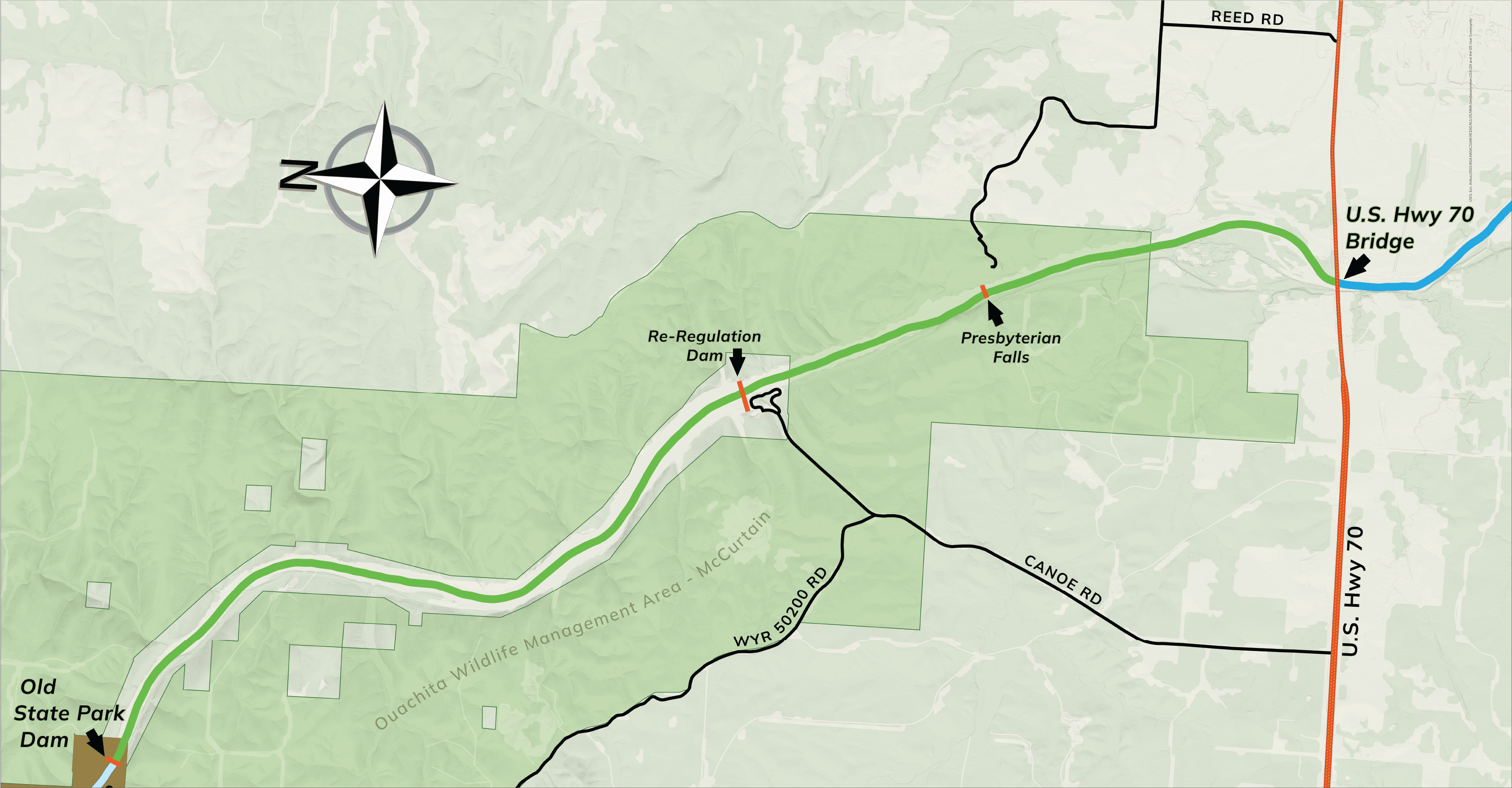
Lower Mountain Fork River
Area 1
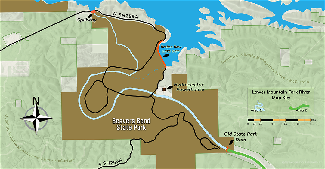
Area 2
Trout Stocking Season
Year-round.
Designated Trout Area/Size/Location
Twelve-mile portion of the Lower Mountain Fork River and its tributaries from the Broken Bow Reservoir Spillway downstream to the U.S. HWY 70 Bridge. About five miles of this designated trout stream lies within Beavers Bend State Park, in McCurtain County.
Bank Access/Boat Ramps
Bank access is unlimited within the state park and downstream to the re-regulation dam. Another public access point exists at Presbyterian Falls. Boat ramps are just upstream of and below the re-regulation dam.
Notes of Interest
Camping and cabin facilities are available within Beavers Bend State Park and below the re-regulation dam. For information, call the park at (580) 494-6300.
Trout Regulations
- Fishing License Required
- BARBLESS HOOKS ONLY
- Use of bait is permitted
- No cast netting
Area 1 (from the Broken Bow Reservoir Spillway downstream to the Old State Park Dam.)
- Daily limit: 3 in aggregate, only one of which may be a rainbow trout greater than 25 inches, and only one of which may be a brown trout which must be greater than 30 inches. Counts towards the aggregate limit for the entire Lower Mountain Fork Trout Area.
Area 2 (from the Old State Park Dam downstream to the US 70 HWY bridge.)
- Rainbow Trout Daily limit: 1; must be greater than 25 inches. Counts towards the aggregate limit for the entire Lower Mountain Fork Trout Area.
- Brown Trout Daily limit: 1; must be greater than 30 inches. Counts towards the aggregate limit for the entire Lower Mountain Fork Trout Area.
Fishing Contact: (918) 683-1031
ANS Alert: Didymo, an aquatic nuisance species commonly referred to as “rock snot,” has been identified in the Lower Mountain Fork River. To prevent spreading this undesirable organism, please clean and dry waders and other fishing equipment after use in the Lower Mountain Fork River.
Blue River
Trout Stocking Season:
Trout are stocked from Nov. 1 through March 31 of the following calendar year.
Designated Trout Area/Size/Location:
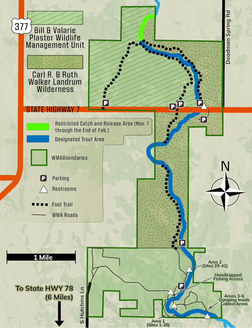
A 6.25-mile portion of the Blue River flowing through the Blue River Public Fishing and Hunting Area located in Johnston County, four miles east of Tishomingo on State Highway 78 and six miles north.
Bank Access:
Bank/wading access is available throughout the area (see accompanying map).
Notes of Interest:
Camping facilities are available only at the Blue River Campground area (see map). Special access is provided for people who use wheelchairs. For information, call (580) 443-5728. For complete public use restrictions, see Department Fishing Areas.
Special Regulations:
From Nov. 1 to the end of February, the portion of the Blue River which enters the north side of the property and flows to the end of the first walk-in trail is catch-and-release only (see shaded area on map) and fishing is restricted to barbless hooks, artificial flies and lures only. Starting March 1, special regulations do not apply. Also, no camping and no vehicles are allowed except in designated parking areas of the Carl R. and Ruth Walker Landrum Wilderness and the Bill and Valerie Plaster Wildlife Management Unit. Nonhunting and nonfishing visitors to the area are required to possess a Oklahoma Fishing, Hunting, Combo or, Wildlife Conservation Passport, unless exempt (see Special Licenses & Permits).
Fishing Contact: (580) 920-5773
Robbers Cave

Trout Stocking Season:
Trout are stocked from Nov. 1 through March 15 of the following calendar year.
Designated Trout Area/Size/Location:
A 1.5-mile portion of Fourche Maline River immediately below Carlton Lake Dam downstream to the southern boundary of Robbers Cave State Park, located in Latimer County, five miles north of Wilburton on State Highway 2.
Bank Access:
Bank access is good because the entire designated trout stream lies within Robbers Cave State Park.
Notes of Interest:
Camping and cabin facilities are available within the state park. For information, call (918) 465-2565.
Fishing Contact: (918) 297-0150
Sunset Lake
Trout Stocking Season:
Trout are stocked from Nov. 1 through March 31 of the following calendar year.
Designated Trout Area/Size/Location:
This 11-acre lake is within Thompson Park at NW 5th Street and Sunset in Guymon.
Bank Access/Boat Ramps:
Bank access is plentiful with a walking trail around the entire lake. There is also a fishing dock. Boats are not allowed.
Notes of Interest:
Lodging is available in Guymon. For information, call the City of Guymon at (580) 338-3396.
Fishing Contact: (580) 327-7029
Medicine Creek
Trout Stocking Season:
Trout are stocked from Nov. 1 through March 15 of the following calendar year.
Designated Trout Area/Size/Location:
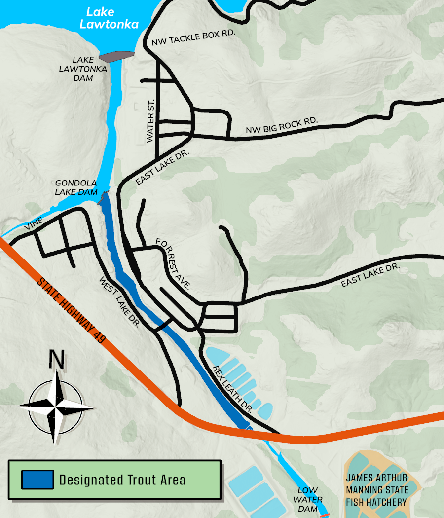
Medicine Creek from Gondola Lake dam downstream to the State Highway 49 bridge.
Bank Access:
A sidewalk along the east side of Medicine Creek in the town of Medicine Park will offer the best fishing access. Parking and fishing access also will be found along the creek's east bank just north of the State Highway 49 bridge. The west side of the creek is mostly undeveloped but is accessible on foot. Anglers should avoid trespassing on any residential property.
Notes of Interest:
Camping facilities are available at the nearby Wichita Mountains Wildlife Refuge. Primitive camping is available on the west side of the trout area along the lower portion of the creek.
For more information, call the refuge headquarters at (580) 429-3222 from 8 a.m. to 4:30 p.m. weekdays. Lodging is available in and around Medicine Park.
Fishing Contact: (580) 529-2795
Lower Illinois River
Trout Stocking Season:
Year-round.
Designated Trout Area/Size/Location:
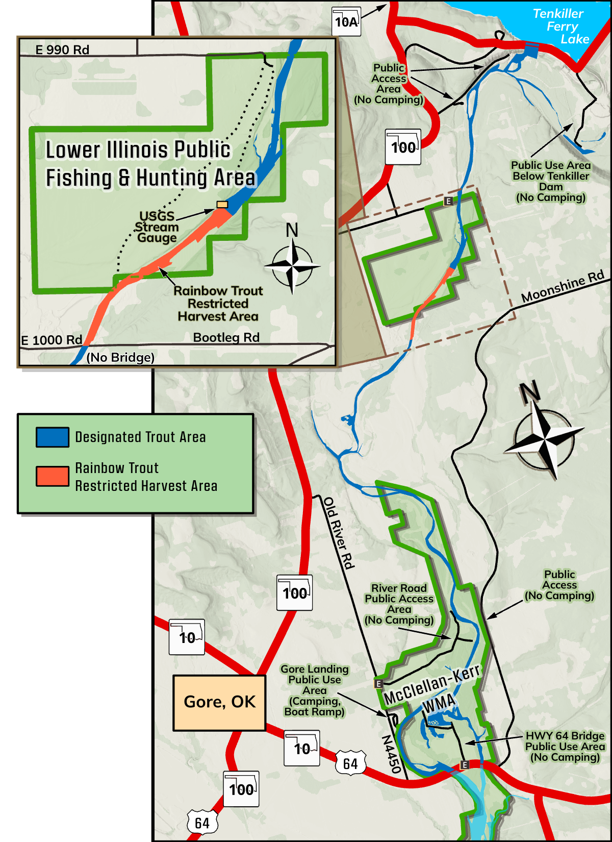
A 7.75-mile portion of the Illinois River from Tenkiller Ferry Dam to the U.S. 64 bridge near Gore in Sequoyah County.
Bank Access/Boat Ramps:
The Lower Illinois River Public Fishing and Hunting Area – Simp and Helen Watts Management Unit offers public fishing access to almost one mile of the trout stream and 320 acres of public hunting opportunity (see map). To reach the area, travel north on State Highway 100 from Gore about four miles. Turn east onto county road E0990 and travel about one mile to the entrance. Park in the designated parking area only. The area is managed for walk-in access only.
Four other public access sites are available along the state-designated trout stream, including a pool off the river located immediately below the dam which allows trout fishing even during high power generation. Another good site is located at the River Road Public Access Area about six miles downstream from the dam. The Gore Landing Public Access Area, operated by the town of Gore, (918) 489-2636, offers camping and a boat launching ramp.
Special Regulations: Daily limit
Daily limit is three trout, only one of which may be a brown trout no less than 20 inches, from USGS stream gauge downstream to Gravel Pit County Road: daily limit is one trout, 20 inch minimum length.
Trout fishing in the Lower Illinois River Simp and Helen Watts Management Unit from the USGS stream gauge downstream to E 1000 Rd is restricted to artificial flies and lures only and barbless hooks only (see Trout Regulations). Single barbed hooks 3/0 or larger may be used only when fishing with natural bait for species other than trout. Artificial baits and treble hooks with barbs when using hooks 3/0 or larger are also allowed when fishing for species other than trout.
Lower Illinois River Public Fishing and Hunting Area
Simp and Helen Watts Management Unit – all general trout fishing regulations apply (see Trout Regulations). No overnight camping is allowed on the area.
Fishing Contact: (918) 683-1031
Lake Carl Blackwell Turtle Pond
All trout stockings from Perry CCC have been diverted to the Turtle Pond at Lake Carl Blackwell.
Trout Stocking Season
Trout are stocked from Nov. 1 to March 31 of the following calendar
year.
Designated Trout Area/Size/Location
Lake Carl Blackwell Park is about 8 miles west of Stillwater at 11000 W State Highway 51. The 2-acre pond is north of the park office between SH 51C and Pine Grove Drive.
Notes of Interest
The Lake Carl Blackwell heated fishing dock is also nearby, allowing for multiple winter fishing opportunities.
Special Regulations
Lake Carl Blackwell offers daily and seasonal permits. For information, call (405) 372-5157 or visit lake.okstate.edu.
Fishing Contact: (580) 304-9243
Lake Watonga/Boecher
Trout stocking during the 2026-27 season may be suspended due to ongoing dam renovations.
Trout Stocking Season
Trout are stocked from Nov. 1 through March 31 of the following calendar year.
Designated Trout Area/Size/Location
Seven miles north of Watonga in Blaine County. This 55-acre lake is within Roman Nose State Park.
Bank Access/Boat Ramps
Bank access and a boat ramp on the west side of the lake.
Notes of Interest
Camping and lodge facilities are available within Roman Nose State Park. For information, call the park at (800) 892-8690.
Fishing Contact: (580) 327-7029